
 Plan Your Trip
Manaslu Circuit Trek – 16 Days
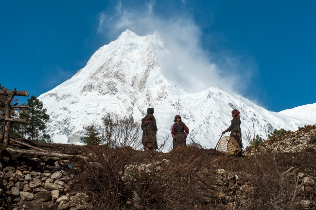

Trip Overview

Trek Region
Manaslu

Difficulty Level
Hard

Transport
Kathmandu–Soti Khola by road; Dharapani–Kathmandu by road

Total Trip Duration
16 Days

Meals
Breakfast, Lunch & Dinner included
Trip Highlights
- Circumnavigate Manaslu (8,163m) — the world’s eighth-highest mountain — in a complete circuit that takes you from its subtropical southern flanks to its Tibetan-influenced northern approaches and back around its western ridges
- Walk the entire length of the dramatic Budhi Gandaki River gorge — one of the deepest and most spectacular river gorges in the Himalayas, with vertical cliffs, thundering waterfalls, narrow trail sections cut into rock faces, and suspension bridges swinging over white water
- Experience the extraordinary cultural transition from Hindu lowland villages near Soti Khola through Gurung and Magar mid-altitude settlements to the deeply Tibetan Buddhist world of Lho, Samagaon, and Samdo — all within a single continuous trek
- Explore the magnificent Lho Monastery (Nyingma Rimjung Gompa) — a 600-year-old monastery perched above Lho village with a direct and extraordinary view of Manaslu’s west face
- Stand at the edge of Birendra Lake (3,450m) — a stunning glacial lake formed from Manaslu’s meltwater, with the enormous south face of the mountain reflected in its still blue-green surface
- Hike to the ancient Pungyen Gompa (4,000m) — a remote monastery above Samagaon with one of the most dramatic close-up views of Manaslu’s north face available from any trail in Nepal
- Reach the Manaslu Base Camp approach (4,800m) optional — one of the least-visited 8,000m base camp areas in Nepal
- Cross the legendary Larkya La Pass (5,106m) — the physical and emotional high point of the circuit — with panoramic views of Manaslu, Annapurna II (7,937m), Himlung Himal (7,126m), Cheo Himal, Kang Guru (6,981m), and dozens of other peaks
- Trek through the Manaslu Conservation Area — a UNESCO-recognized biodiversity zone and one of Nepal’s most ecologically diverse protected areas, home to snow leopard, red panda, Himalayan tahr, musk deer, and over 200 bird species
- Walk an ancient Tibet trade route — the Budhi Gandaki valley was historically one of the primary trade corridors between Nepal and Tibet, and the cultural legacy of that trade is visible in every village above Deng
- Descend through the beautiful post-pass landscape of Bimthang (3,720m) — a wide alpine valley with spectacular views of Manaslu’s southwest face, Phungi Himal, and Lamjung Himal
- Complete a genuine circuit — starting at Soti Khola and finishing at Dharapani on the Marsyangdi River — with entirely different scenery in every stage and a connection to the Annapurna Circuit trail system at the end
- Trek on a Restricted Area route where the mandatory licensing system keeps trail traffic a fraction of the Annapurna or Everest routes — genuine solitude in the upper circuit, genuinely authentic village encounters throughout
Trip Summary
Nepal has a handful of trekking circuits that belong in a category of their own routes that combine spectacular mountain scenery with genuine cultural immersion, physical challenge with rewarding diversity of terrain, and accessibility with enough remoteness to feel like a genuine expedition. The Manaslu Circuit Trek is one of that handful. And unlike the famous circuits of the Annapurna and Everest regions, it carries a legal protection that keeps it from ever becoming crowded a Restricted Area Permit that requires all trekkers to be accompanied by a licensed guide.
The circuit circumnavigates Manaslu (8,163m) the eighth-highest mountain in the world and the highest peak entirely within Nepal following the ancient trade and pilgrimage route along the Budhi Gandaki River from the subtropical lowlands of the Gorkha district northward through one of the most dramatic river gorges in the Himalayas. As the trail climbs, the culture shifts completely from the Hindu Brahmin and Chhetri villages of the lower gorge, through the mixed Magar and Gurung communities of the mid-altitude forests, into the deeply Tibetan Buddhist world of the upper circuit at Lho, Samagaon, and Samdo flat-roofed stone houses, butter tea, ancient gompas, yak herds, and the massive south face of Manaslu rising directly above.
The circuit culminates in the crossing of Larkya La Pass (5,106m) the highest and most demanding point of the entire circuit, before descending into the Marsyangdi River valley and connecting with the Annapurna Circuit trail system at Dharapani.
This 16-day itinerary is the most complete and most comfortably paced version of the Manaslu Circuit starting from Soti Khola, including a full acclimatization day at Samagaon with an optional side trip to the stunning glacial Birendra Lake and the ancient Pungyen Gompa, a second acclimatization movement day at Samdo, proper buffer time in Kathmandu, and enough days at each significant stage to genuinely experience the villages, monasteries, and landscapes rather than simply passing through them.
When To Visit
The Manaslu Circuit’s particular seasonal character is shaped by the Larkya La Pass crossing at 5,106m — the condition of the pass in different seasons determines not just the difficulty of the crossing but whether it is safely possible at all.
Autumn (September to November) is the best and most popular season for the circuit. After the monsoon clears in mid-September, the trail conditions are excellent, the teahouses are fully stocked and staffed, and the mountain views from the entire upper circuit are at their annual finest. October delivers the clearest skies and the best panoramas from the pass. The cultural villages are at their most active during this period harvest festivals and the Tibetan Buddhist calendar create a particularly rich atmosphere in the upper villages around October and November. November remains excellent but becomes colder at altitude and some higher teahouses begin reducing services.
Spring (March to May) is the second-best season. The lower gorge sections are warm and lush, and the rhododendron forests in bloom from March through April are spectacular. The Larkya La has accumulated winter snowpack through March and the crossing can be more demanding and require crampons in heavy snow years. By April the pass is generally clear and the crossing is reliable. May is warm and the views are good, though pre-monsoon haze builds in late May.
Winter (December to February) is cold, demanding, and beautiful in its own way for the lower circuit sections. The Larkya La crossing in deep winter (December to February) involves significant snowpack, potential ice on the approach glacier, and extreme cold at Dharamsala and the pass. Only for very experienced cold-weather trekkers with proper gear and a guide experienced in winter Manaslu crossings. Some high-altitude teahouses close in deep winter.
Monsoon (June to August) is not recommended. The lower Budhi Gandaki gorge is particularly susceptible to landslides and flooding during the monsoon, the trail becomes dangerous in multiple sections, and the mountain views are obscured for weeks at a time. The upper circuit sections above Samagaon are more sheltered from monsoon rainfall but the approach and return roads become severely affected.
Itinerary
Welcome to Nepal. Our team meets you at Tribhuvan International Airport and transfers you to your hotel in Kathmandu. In the evening your trekking guide joins you for a thorough pre-trek briefing covering the full 16-day circuit day by day, the cultural and ecological context of the Manaslu Conservation Area, altitude profiles and acclimatization strategy, the Restricted Area Permit requirements and checkpoint protocols throughout the trek, gear checks, and the logistics of the early morning road drive to Soti Khola tomorrow.
The briefing covers the Manaslu Circuit’s particular character the way the landscape and culture transform gradually as you climb northward through the Budhi Gandaki gorge, the significance of the Larkya La Pass crossing and why the acclimatization days at Samagaon and Samdo are non-negotiable safety components of the itinerary, and what to expect from the Tibetan Buddhist culture of the upper circuit villages where you will spend the most rewarding cultural days of the entire trek.
If you arrive with energy, Kathmandu has no shortage of evening destinations the Boudhanath Stupa neighborhood a short taxi ride away offers excellent restaurants and the beautiful evening circumambulation of one of the world’s great Buddhist monuments. Overnight in Kathmandu.
An early morning departure from Kathmandu for the long road journey west through the Gorkha district to the Manaslu Circuit trailhead. The route follows the Prithvi Highway westward toward Pokhara before branching north at Dumre and then taking the rougher, more dramatic road through Arughat to Soti Khola (730m) on the Budhi Gandaki River.
The road journey is long 7 to 9 hours depending on road conditions and traffic, and becomes progressively rougher and more interesting after Arughat as the road enters the hill country. The final section to Soti Khola follows the Budhi Gandaki river valley northward and offers your first glimpses of the gorge country that will define the walking for the next several days. The character of the landscape changes noticeably from the open Pokhara Highway corridor to the narrow, forested river valley of the upper Gorkha district.
Soti Khola (730m) is a small riverbank settlement at the southern entrance to the Manaslu Conservation Area a handful of teahouses on the banks of the Budhi Gandaki where the mountains close in on both sides and the river runs fast and green over the boulders below. Check in, eat a proper meal, and rest for the first walking day tomorrow. Drive time: 7–9 hours.
The first walking day and an immediate immersion into the distinctive character of the lower Budhi Gandaki gorge. From Soti Khola the trail enters the river gorge directly crossing and recrossing the Budhi Gandaki on suspension bridges, following narrow ledge paths cut into the rock face above the water, passing through dense subtropical forest of sal, bamboo, and fern, and crossing several tributaries on wooden bridges through deep jungle side ravines.
The lower gorge is one of the most physically dramatic sections of any Nepal teahouse circuit at this altitude vertical cliffs dropping directly to the river, waterfalls emerging from the rock face above the trail, the constant sound of the river filling the gorge below, and the occasional section where the trail narrows to a meter-wide ledge above a serious drop. This is not technical terrain but it is dramatic terrain, and the combination of river gorge walking, lush subtropical vegetation, and the first glimpses of high snow peaks visible above the gorge walls makes the lower Manaslu section immediately and entirely compelling.
The trail passes through the small villages of Gurung-chhap and Lapubesi before arriving at Machha Khola (930m) a small riverside settlement named for the fish (machha) found in the cold Budhi Gandaki waters. Walking time: 5–6 hours.
Another spectacular day through the deepening Budhi Gandaki gorge. The trail continues its pattern of river crossings, ledge paths, forested sections, and dramatic suspension bridge crossings through increasingly narrow gorge terrain. The settlements along this section Kholabesi, Tatopani, and the approach to Jagat are a mix of Gurung, Magar, and lower-caste Hindu communities whose villages sit in the small riverside flats between the gorge walls.
The village of Tatopani along this section is named for its natural hot springs an atmospheric natural geothermal source on the river bank where local communities have bathed for generations. A short detour and a soak is a genuine pleasure after a morning of gorge walking.
Jagat (1,340m) is the first major permit checkpoint on the circuit the point where the Restricted Area Permit and Manaslu Conservation Area Permit are both checked and stamped. It is also the first significant village of the upper Manaslu corridor and where the character of the trail community begins to shift. The checkpoint process is straightforward and your guide manages all permit documentation. Jagat has a good selection of teahouses and the village has a more established trekking infrastructure feel than the simpler lower gorge settlements. Walking time: 6–7 hours.
One of the longest walking days of the entire circuit and one of the most visually dramatic. From Jagat the trail continues northward through the gorge the valley walls closing in and then opening, the river crossing in both directions multiple times on suspension bridges, the forest changing gradually from subtropical sal and bamboo to more temperate mixed vegetation.
The trail passes through Salleri, Sirdibas, and Philim a large and prosperous Gurung and Magar settlement spread across a wide river flat, with terraced millet fields, water buffaloes grazing, and traditional thatched houses that carry a warm agricultural character entirely different from the higher Tibetan villages ahead. Above Philim the valley narrows dramatically at Ekle Bhatti a section of the gorge where the walls close to almost nothing above the river and the trail involves some of the most dramatic narrow ledge walking of the lower circuit.
Deng (1,860m) is the first village on the circuit with a distinctly Buddhist character mani walls begin appearing beside the trail, carved prayer stones are set into the rock faces above the path, and a small chorten marks the entrance to the village. From Deng on clear days, the first distant glimpse of Manaslu (8,163m) appears above the valley a brief, tantalizing preview of the mountain that will dominate the entire upper circuit. Walking time: 6–7 hours.
The trail above Deng enters a new world. The subtropical vegetation of the lower gorge gives way progressively to temperate forest first mixed broadleaf, then stands of oak, maple, and birch, and finally the first scattered rhododendron and bamboo that signal the mid-altitude transition zone. The Budhi Gandaki gorge remains impressive and dramatic above Deng but the character is more open, more alpine, and increasingly more Tibetan in its cultural expression.
The route passes through the village of Rana where a large wooden suspension bridge crosses the river to a dramatically positioned cluster of stone houses, and then through Bihi Phedi and Ghap, where mani walls become longer and more elaborate and the first proper prayer wheel structures appear at the village entrances. Ghap has an impressive stone mani wall extending for nearly 100 meters beside the trail one of the finest examples of this Tibetan Buddhist tradition on the entire circuit and the village gompa, small but active, is worth a brief visit.
Above Ghap the trail climbs steeply through pine and fir forest, crossing several streams on wooden bridges, before arriving at Namrung (2,630m) a well-established mid-circuit teahouse village with good facilities and the first genuinely expansive mountain views of the upper Manaslu massif appearing above the ridge. The air at 2,630m is noticeably cooler and the mountain scale visible from Namrung Manaslu, Himal Chuli (7,893m), Peak 29 (Ngadi Chuli, 7,871m) is a powerful signal of what lies ahead. Walking time: 6–7 hours.
A shorter and deeply rewarding walking day that earns its place in the itinerary not through distance covered but through one of the finest cultural and scenic experiences on the entire circuit. From Namrung the trail climbs through open forest and then alpine meadow to Lho (3,180m) a beautifully positioned Tibetan Buddhist village on a broad south-facing plateau with an unobstructed, direct, and overwhelming view of Manaslu’s west face.
Lho is the village where the transformation from Hindu Nepali lowland culture to Tibetan Highland Buddhist culture becomes complete and unmistakable. The village architecture changes to flat-roofed stone houses. The women wear traditional Tibetan dress and coral-and-turquoise jewelry. Butter tea is available at the teahouses. Prayer flags cover every roof and string between the houses in long, wind-animated arcs.
Above the village, the Nyingma Rimjung Gompa also called Lho Monastery, is a working religious site of extraordinary significance. Founded over 600 years ago, the monastery sits on a natural terrace above Lho with Manaslu’s west face directly in the frame of its courtyard a view of almost theatrical drama that makes the monastery one of the most photographed religious buildings in the Manaslu region. Spend the afternoon here. Walk through the monastery with your guide, observe the ancient thangka paintings and butter lamp shrines, spin the prayer wheels outside, and sit in the courtyard with Manaslu above you. This is one of the finest single monastery experiences on any Nepal teahouse circuit. Walking time: 4–5 hours.
From Lho the trail continues north through increasingly open and high alpine terrain the forest thinning to scattered juniper and fir, the yak pastures widening, and the full Manaslu massif filling the northern skyline with greater drama at every step. The trail passes through Shyala (3,520m) a small settlement on a wide grassy terrace where the view of Manaslu, Ganesh Himal, Himal Chuli, and Peak 29 is perhaps the most panoramic mid-circuit mountain viewpoint on the entire circuit before making the short final descent to Samagaon.
Samagaon (3,530m) also written as Sama Gaun is the largest and most comfortable settlement in the upper Manaslu circuit and the primary acclimatization hub before the high section. The village is a beautifully preserved example of upper-altitude Tibetan Buddhist settlement Ribung Gompa, the village monastery, is richly decorated and actively attended by local monks, and the community life of Samagaon carries the unhurried dignity of a place that has been managing the balance between the Himalayan mountain world and Tibetan Buddhist tradition for centuries.
Settle into your teahouse, rest, hydrate generously, and eat well. Tomorrow is an acclimatization day here — a full day dedicated to going higher and coming back, exploring the extraordinary natural and cultural highlights directly above the village. Walking time: 3–4 hours.
The finest acclimatization day of the entire 16-day circuit a day that many trekkers consider the most memorable single day of the Manaslu Circuit experience. Two extraordinary destinations are within reach of Samagaon on an acclimatization day, and the 16-day itinerary allows time for both.
Birendra Lake (3,450m) is a glacial lake formed from Manaslu’s meltwater, named after the former King of Nepal, sitting in a natural bowl approximately 25 minutes above the village. The lake is one of the most beautiful natural features on the entire circuit its surface a deep turquoise-blue, perfectly still in the morning air, with the enormous south face of Manaslu (8,163m) reflected in the water. The silence at the lake is remarkable. Sit for a while here, watch the mountain in the water, and absorb the scale of what surrounds you.
Pungyen Gompa (approx. 4,000m) is an ancient monastery above Samagaon that rewards a more demanding climb approximately 1.5 hours of steep uphill from the village. The gompa sits on a high terrace with one of the most extraordinary and intimate close-up views of Manaslu’s north face available from any trekking trail in Nepal. The monastery is several hundred years old and still actively maintained by a small community of monks. The combination of ancient religious architecture, the prayer flag-decorated compound, and the overwhelming scale of Manaslu directly above creates an atmosphere that is genuinely unlike anything else on the Manaslu Circuit.
Return to Samagaon for the afternoon and rest well. The altitude work of today going up to 4,000m and coming back, is preparing your body for the upper circuit days ahead. Total exploration time: 4–5 hours.
A shorter walking day of significant cultural interest. From Samagaon the trail heads northeast toward the Tibet border climbing through wide open alpine terrain of grass and rock with increasingly dramatic views of the Manaslu massif from new angles. The landscape here takes on a distinctly Tibetan character sparse, open, wind-swept, and beautiful in a clean, uncluttered way that feels entirely different from the lush gorge forest of the lower circuit.
The route passes a series of prayer flag poles and mani stones marking the trail between Samagaon and the upper valley, and the scale of the surrounding peaks Manaslu, Peak 29, Himalchuli, Kang Guru grows continuously. Small yak herding shelters dot the hillsides, and in the autumn you may encounter herding families driving their animals down from the high summer pastures.
Samdo (3,875m) is the last permanently inhabited village before the Larkya La crossing — a cluster of stone houses near the Tibetan border whose residents practice a form of Tibetan Buddhism that retains a purity and authenticity of practice not widely found in more accessible villages. The small Samdo monastery is worth visiting in the afternoon. The Tibetan border ridge is visible above the village on clear days the plateau of Tibet itself shimmers beyond the frontier ridge, an extraordinary geographical and cultural proximity. Walking time: 3–4 hours.
A second acclimatization movement day this one at 3,875m before the jump to Dharamsala at 4,460m and the Larkya La crossing the day after. The standard acclimatization hike from Samdo heads northward toward the Rui La Pass (5,095m) the border crossing into Tibet climbing to approximately 4,500m on the approach before returning. This hike provides both excellent altitude adaptation and extraordinary views of the Tibetan plateau country and the border range peaks.
An alternative option is the hike to Samdo Ri a high ridge above the village that provides an excellent panorama of the entire upper Manaslu circuit from above. Your guide selects the most appropriate acclimatization route based on current conditions and the group’s altitude response.
The afternoon is spent at Samdo resting, eating, hydrating, organizing gear for the Larkya La crossing, and going to bed early. Dharamsala tomorrow. The pass the day after. The altitude adaptation work of today is the final and most important physiological preparation before the highest point of the entire circuit. Hike time: 3–4 hours.
A short walking day by distance but a significant one by altitude climbing from 3,875m at Samdo to Dharamsala (4,460m) in just 3–4 hours, gaining nearly 600m of altitude in one of the most dramatic approach sections of the circuit. Dharamsala also called Larkya Phedi (base of Larkya Pass), is the last settlement before the pass, a basic cluster of stone teahouses and shelters huddled on the moraine below the Larkya Glacier approach.
The trail from Samdo crosses the open upper valley floor, passing several glacial streams and moraine ridges, with the Larkya Glacier visible ahead and the massive flanks of Larkya Peak (6,249m) and the Larkya Himal rising above the valley on the north side. The scale of the terrain here the wide, glacial basin, the rock and ice walls on all sides, the absence of any vegetation above 4,000m is genuinely expedition-grade wilderness even without being on a technical mountaineering route.
At Dharamsala, organize everything for tomorrow morning’s pre-dawn start. Lay out your clothing layers in the order you will put them on. Fill water bottles with purified water. Eat the best dinner you can manage at altitude. Set your alarm early. The Larkya La crossing requires the longest, most demanding, and most rewarding walking day of the entire circuit. Walking time: 3–4 hours.
The defining day of the entire 16-day circuit. Everything that has come before the gorge walking, the cultural villages, the acclimatization days, the altitude gains has been leading to this crossing.
The alarm sounds at 4:00 AM or earlier. In the pre-dawn darkness you eat breakfast in the mess hall at Dharamsala, layer up completely base layer, mid-layer, down jacket, hardshell, warm hat, gloves, gaiters and begin the approach to the Larkya La. In the winter months and early spring, crampons may be required near the pass summit. Your guide assesses current conditions and advises accordingly.
The climb from Dharamsala to the pass gains nearly 650m in altitude on a trail that crosses the Larkya Glacier on the approach a journey through a raw, primeval landscape of ice, moraine, and rock that begins in darkness and arrives at the pass in the early morning light. The gradient is sustained and the altitude makes every step deliberate. Go slowly. Breathe steadily. One step at a time.
At Larkya La Pass (5,106m), a cluster of prayer flags marks the highest point of the entire Manaslu Circuit. The panoramic view from the pass is one of the most extraordinary accessible from any standard Nepal teahouse circuit. Manaslu (8,163m) rises directly east the mountain you have been circling for over a week, now seen from its western aspect in full massif width. Annapurna II (7,937m) appears to the southwest. Himlung Himal (7,126m), Cheo Himal (6,820m), Kang Guru (6,981m), and dozens of lesser peaks form a continuous white horizon in every direction. This is the summit of the Manaslu Circuit in every sense altitude, panorama, and the particular satisfaction of standing at the highest point of a journey well walked.
The descent from the pass to Bimthang (3,720m) is long, steep, and rocky nearly 1,400m of descent on a trail that becomes less icy and more rocky as altitude drops. The descent reveals a completely new landscape the wide, open, glacially-carved basin of Bimthang with its dramatic views of Manaslu’s southwest face, Phungi Himal (6,538m), and Lamjung Himal (6,983m) appearing above the valley. Bimthang is one of the finest overnight stops on the entire circuit a wide alpine valley that feels like a reward after the demanding pass crossing. Walking time: 8–10 hours.
The long post-pass descent day a continuous descent of over 2,000m that takes you from the high alpine world of Bimthang back into the warm, forested, lower-altitude landscape of the Marsyangdi River system. The descent is long and the knees feel it by the end, but the ecological transition from high alpine to temperate to subtropical vegetation unfolding in reverse over the course of one walking day is one of the most visually dramatic natural experiences of the entire trek.
From Bimthang the trail drops through the broad alpine valley, passing the small settlement of Hampuk, and then enters increasingly dense forest as the altitude drops first rhododendron and birch, then oak and chestnut, then the warm, humid mixed forest of the lower Marsyangdi approach. The trail passes through Goa and the larger village of Tilje (1,700m) a Gurung community in the lower Marsyangdi valley where the subtropical warmth and the sound of running irrigation channels signal the return to a fully human, agricultural, warm-climate world.
The contrast with the glacier and the pass barely more than a day behind you is vivid and satisfying. Your body descends gratefully through the thickening air. Walking time: 6–7 hours.
The final walking day of the Manaslu Circuit and the road connection back to Kathmandu. From Tilje the trail makes a short, pleasant walk of 2–3 hours through the lower Marsyangdi valley passing through the villages of Thonje and arriving at Dharapani (1,860m) the junction point where the Manaslu Circuit trail connects with the Annapurna Circuit trail. The teahouses and trekkers of the Annapurna Circuit appear at Dharapani like an arrival at a busy crossroads after the relative solitude of the Manaslu trail.
From Dharapani, a private jeep arranged by your trekking company begins the road journey back to Kathmandu via Besisahar and the Prithvi Highway. The drive takes 6–8 hours depending on road and traffic conditions and follows the Marsyangdi River southward before joining the main highway westward toward Pokhara and then east to Kathmandu.
Back in Kathmandu, transfer to your hotel and enjoy the fully earned comforts of the city — a hot shower, a proper meal, and the particular satisfaction of having walked around an 8,000m mountain in its entirety. Walking time: 2–3 hours. Drive time: 6–8 hours.
A practical buffer day built into the itinerary for any road delays, weather disruptions, or logistics events affecting the return journey from Dharapani mountain road conditions in the Gorkha and Lamjung districts can occasionally be affected by seasonal landslides or local traffic events.
If your return went smoothly, you have a free day in Kathmandu use it for any of the UNESCO heritage sites you may not have visited, a cooking class, a massage, shopping in Thamel, or a day trip to Bhaktapur or Nagarkot. Our team transfers you to the international airport for your departure flight whenever your schedule requires.
Trek Difficulty & Physical Demands
The Manaslu Circuit Trek is rated strenuous to challenging a demanding and serious Himalayan circuit that is significantly more demanding than the Annapurna Base Camp or Langtang Valley routes but broadly comparable in physical demand to the Everest Three Passes Trek.
Altitude: The circuit reaches 5,106m at Larkya La Pass the highest teahouse circuit pass in Nepal’s restricted area trekking routes. The acclimatization structure of the 16-day itinerary with a full rest and exploration day at Samagaon (3,530m), a movement acclimatization day at Samdo (3,875m), and only a short final push to Dharamsala (4,460m) before the pass is specifically designed to give the body maximum adaptation time before the highest point. Following this structure is not optional rushing the acclimatization days significantly increases altitude sickness risk on the pass.
Larkya La crossing day: 8–10 hours of sustained effort from a pre-dawn start, gaining and then losing nearly 2,000m of altitude in a single day, at altitudes where the oxygen level is approximately 50% of sea level. This is the single most demanding day of the circuit and the day that separates the Manaslu Circuit from lower-altitude routes. Crampons and gaiters may be required depending on conditions.
Lower gorge section: The Budhi Gandaki gorge between Soti Khola and Deng involves some exposure on narrow ledge trails above the river. Not technical but requiring sure footing and confidence on narrow paths with significant drop exposure.
Daily walking: Expect 4–7 hours of walking per day with variation — the acclimatization days are shorter and the longer gorge days and the pass crossing day are the most demanding. The descent from Larkya La to Bimthang (1,400m of descent in a single afternoon) puts significant pressure on knees and requires trekking poles.
Physical fitness: 3–4 months of consistent cardiovascular training before departure — hiking with a loaded pack, running, stair work, and cycling is the appropriate preparation. Prior high-altitude trekking experience above 4,000m is a meaningful advantage but not strictly required if the acclimatization structure is followed and your guide’s advice is respected throughout.
The Restricted Area advantage: The mandatory guide requirement means this circuit is always trekked with professional support a genuine safety advantage compared to self-guided routes on the Annapurna or Langtang trails.
Best Time to Trek: Seasonal Comparison
| Season | Months | Weather | Pass Conditions | Views | Recommended |
| Spring | Mar–May | Warm & Stable | Good from April | Excellent | Good |
| Monsoon | Jun–Aug | Wet & Risky | Dangerous | Poor | Avoid |
| Autumn | Sep–Nov | Cool & Clear | Excellent | Outstanding | Best |
| Winter | Dec–Feb | Cold & Dry | Heavy Snow | Good (lower) | Experienced Only |
Pro tip: For the Larkya La specifically, October and early November are the two finest months, offering consolidated snow on the pass approach (without the icy unpredictability of the spring melt or the deep winter snowpack), crystal-clear summit views, and vibrant village life during the autumn harvest and Tibetan Buddhist festival season. Book early if you’re planning to trek in October, as the Manaslu Circuit, despite its restricted-area permit requirements, reaches high demand during peak season.
Booking Your Manaslu Circuit Trek – 16 Days
Booking the Manaslu Circuit requires a little more advance notice than standard open-access Nepal treks the Restricted Area Permit takes time to process and we recommend allowing at least 3–4 weeks lead time, or 6–8 weeks for peak October departures.
Step 1 — Contact us. Reach out via our website, email, or WhatsApp with your preferred travel dates and group size. We respond within 24 hours with the complete 16-day itinerary and full cost breakdown including current RAP permit pricing for your season.
Step 2 — Confirm your booking. A 20% deposit secures your dates. We immediately begin the RAP permit application process which requires passport copies and personal information for all trekkers and arrange ground transport logistics for both entry and exit road legs.
Step 3 — Prepare. We send a comprehensive pre-departure guide covering fitness training recommendations, detailed gear list, cultural etiquette for the Tibetan Buddhist communities of the upper circuit, altitude awareness specific to the Larkya La section, whether to carry crampons based on current seasonal conditions, and day-by-day expectations for all 16 days.
Step 4 — Arrive in Kathmandu. We collect you from the airport, conduct a full pre-trek briefing with your guide, process any remaining permit documentation, help with gear needs in Thamel, and brief you on the Restricted Area permit checkpoint system along the route. The private jeep to Soti Khola departs early the following morning.
Step 5 — Trek. Your licensed guide leads you through the full circuit from Soti Khola to Dharapani, managing all permit checkpoints along the route and providing the cultural and ecological knowledge that makes this restricted circuit genuinely rewarding.
Step 6 — Pay the balance. The remaining 80% is due on arrival in Kathmandu before departing for Soti Khola.
Cancellation Policy:
- 30+ days before departure: Full deposit refunded minus bank transfer charges and non-refundable RAP permit fees
- 15–29 days before: 50% refund minus permit fees
- Less than 15 days: Deposit forfeited, no refund
- Note: RAP permits once processed are non-refundable regardless of cancellation date
Travel Insurance — Mandatory: Travel insurance with emergency helicopter evacuation coverage above 5,500m is mandatory for all trekkers on this circuit. A helicopter rescue from the Larkya La or Dharamsala area costs USD 4,000–7,000 or more. Your guide requires a copy of your insurance documents before departure from Kathmandu.
Cost Details
Cost Includes
- Airport pick-up and drop-off in Kathmandu
- Kathmandu–Soti Khola private jeep ground transportation
- Dharapani–Kathmandu return private jeep ground transportation
- 1 night hotel accommodation in Kathmandu on arrival (bed & breakfast, 3-star)
- All teahouse accommodation during the trek (13 nights)
- All meals during the trek — breakfast, lunch, and dinner every day on trail
- Experienced, English-speaking, government-licensed trekking guide (mandatory for Restricted Area)
- One porter for every two trekkers (maximum 15 kg per porter load)
- All required permits:
- Manaslu Restricted Area Permit (RAP) — mandatory, included
- Manaslu Conservation Area Permit (MCAP)
- Annapurna Conservation Area Permit (ACAP) — for Dharapani exit section
- TIMS Card (if required — as of 2025 TIMS is no longer mandatory for this route; we confirm current requirements at booking)
- Guide and porter wages, meals, accommodation, and full insurance
- All government taxes and local charges
- Sleeping bag and duffel bag rental (if needed)
- First Aid Kit including pulse oximeter carried by guide throughout
- Emergency evacuation arrangement (evacuation cost covered by your travel insurance)
Cost Excludes
- Nepal entry visa fee (approx. USD 50 for 30 days)
- International flights to and from Kathmandu
- Travel insurance with emergency helicopter evacuation coverage (mandatory)
- Meals in Kathmandu beyond breakfast
- Hot showers, Wi-Fi, and device charging along the trek (charged at teahouses — typically USD 2–5 per item)
- Personal snacks, bottled water, energy drinks, and alcoholic beverages
- Tips and gratuity for guide and porter (strongly recommended)
- Personal trekking gear and clothing
- Extra nights in Kathmandu beyond the planned itinerary
- Helicopter rescue costs (covered by personal travel insurance)
- Monastery entry donations at Lho, Samagaon, and Samdo
- Personal expenses — laundry, souvenirs, phone calls, incidentals
Trip Gallery
Trek Essentials
- Thermal base layer top and bottom — 2 sets
- Mid-layer fleece or softshell jacket
- Warm down jacket or insulated puffy — essential from Namrung upward and critical at Dharamsala and the pass where overnight temperatures fall well below zero
- Waterproof, windproof hardshell jacket and trousers — essential for the Larkya La crossing and any precipitation in the gorge sections
- Trekking trousers — 2 to 3 pairs
- Lightweight trekking shirts for the warm lower gorge sections (Days 3–5)
- Warm trekking socks, wool or synthetic — 5 pairs for 13 trekking days
- Thin liner gloves and warm outer gloves or mittens — both needed for Dharamsala and the pass
- Warm beanie or wool hat — worn daily above 3,500m
- Sun hat or cap with brim for lower gorge sections
- Neck gaiter or buff — critical at the Larkya La
- Waterproof, ankle-support trekking boots — broken in thoroughly before departure. The lower gorge ledge paths and the Larkya La approach demand good ankle support and reliable grip.
- Lightweight sandals for warm teahouse evenings in the lower gorge
- Gaiters — strongly recommended for the Larkya La crossing where snow is common on the pass approach
- Crampons (lightweight micro-spikes or 6-point crampons) — not always required but strongly recommended to carry; conditions at the pass vary significantly by year and season. Can be rented in Kathmandu.
- Trekking poles — both collapsible; essential for the 1,400m post-pass descent to Bimthang and the ledge sections of the lower gorge
- Daypack (20–25 liters) for daily trail essentials
- Duffel bag (60 liters) for your porter
- Sleeping bag rated to -15°C — Dharamsala at 4,460m is the coldest overnight of the circuit and basic stone teahouse walls provide minimal insulation
- Headlamp with spare batteries — the pre-dawn Larkya La start requires 3+ hours of reliable lighting
- Quality sunglasses with UV400 protection — glacier reflection on the Larkya La approach is intense
- Water bottle (2 liters) or hydration bladder — higher flow rate sections of the gorge make refill opportunities easy but quality varies; purification essential
- Water purification tablets or personal filter
- Diamox (acetazolamide) — consult your doctor before the trek; strongly recommended for the Larkya La approach given the sustained days above 4,000m
- Personal pulse oximeter — monitoring blood oxygen saturation above 3,500m provides concrete data for both you and your guide
- Personal first aid kit — blister pads, ibuprofen, bandages, antiseptic cream
- Sunscreen SPF 50+ and SPF lip balm — particularly important at the pass and on open glacier terrain
- Hand sanitizer and biodegradable wet wipes
- Insect repellent — genuinely needed in the warm lower gorge sections below Deng
- Diarrhea medication and oral rehydration salts
- All personal prescription medications for the full 16-day duration
- Valid passport with at least 6 months remaining validity
- Nepal visa (obtainable on arrival at Kathmandu airport)
- Printed travel insurance policy with emergency evacuation details — your guide requires a copy before departure
- 2 passport-sized photos (for RAP permit processing)
- Emergency contact card on your person throughout
Final Thoughts:
The Manaslu Circuit Trek earns its reputation as one of the finest trekking circuits in Nepal through a combination of qualities that no single route element could deliver alone. It is the deepest river gorge approach of any major Nepal circuit. It is the most complete cultural transition from Hindu lowland to Tibetan highland available in a single continuous trek. It has the finest mid-circuit monastery experience in Nepal at Lho. It has the most dramatic and most intimate base camp approaches to an 8,000m peak accessible from a teahouse circuit. And it has the Larkya La a pass crossing that is demanding, physical, and panoramically extraordinary in a way that fully justifies the days of preparation that lead to it.
The Restricted Area Permit that many trekkers initially see as a bureaucratic inconvenience turns out to be one of the circuit’s greatest assets. The licensing system keeps trail traffic low enough that the upper Manaslu villages Lho, Samagaon, Samdo, have not been transformed by the kind of tourist-infrastructure development that has changed many villages in the Khumbu and Annapurna regions. The monks at Lho Monastery still have time for a conversation. The butter tea in Samagaon is still made the way it has always been made. The herders at Samdo still drive their yaks to the same high pastures in summer that their grandparents used. The Restricted Area permit, in effect, protects the very thing that makes the Manaslu Circuit worth doing.
Come properly prepared physically fit, well-equipped, and with enough days in the itinerary to actually acclimatize and absorb what you are walking through. The 16-day version is the right version. It gives you the acclimatization days at Samagaon and Samdo that make the Larkya La crossing safe and enjoyable rather than rushed and risky. It gives you the afternoon at Lho Monastery that most 13-day versions skip. It gives you Birendra Lake and Pungyen Gompa on a full exploration day rather than a rushed morning detour.
Around an 8,000m mountain on foot, properly, without crowds, through living Tibetan Buddhist culture, and over one of the finest Himalayan passes on any standard trekking circuit in Nepal. That is the Manaslu Circuit. It is worth every day it takes.
Your Adventure to Manaslu Circuit Trek – 16 Days Starts Here
Start your journey with trusted local experts and discover the beauty, culture, and adventure waiting in the Himalayas and beyond.
Frequently Asked Questions
Everything you need to know about the AASRA ECO TREK
The Manaslu Restricted Area Permit (RAP) is a special permit issued by the Government of Nepal’s Department of Immigration that is required for all trekkers entering the restricted zone of the Manaslu Conservation Area — specifically the section from Jagat through the upper circuit to Samagaon. The restricted area designation was established to protect the ecological and cultural integrity of the upper Budhi Gandaki valley and its Tibetan Buddhist communities, limit trekker numbers to sustainable levels, and ensure that trekking income contributes to local conservation and community development. The permit requirement means a licensed guide must accompany all trekkers a rule that genuinely benefits trekkers as well as the environment and communities.
Generally yes, for two primary reasons: the Larkya La Pass at 5,106m is surrounded by fewer teahouse services and has a longer, more remote feel than the Thorong La on the Annapurna Circuit, and the lower gorge sections of the Budhi Gandaki are more physically demanding and more exposed on narrow ledge paths than the equivalent lower sections of the Annapurna approach. The Manaslu Circuit is also less well-developed in terms of teahouse infrastructure above Samagaon the facilities at Dharamsala are very basic compared to equivalent pre-pass teahouses on the Annapurna. However, the Manaslu Circuit is lower at its highest point (5,106m vs Thorong La’s 5,416m) which partially offsets the greater overall difficulty.
Yes. The Restricted Area Permit cannot be obtained without a licensed guide this is a Nepal Government regulation, not a tour operator preference. Solo trekking in the Manaslu restricted zone is not legally permitted. Any permit issued requires the name of a licensed guide and a licensed trekking company. Trekkers who attempt to enter the restricted zone without a guide face permit confiscation at the checkpoints. This regulation is enforced at multiple checkpoints between Jagat and Samagaon.
The Restricted Area Permit is charged per person per week. In peak season (September to November): USD 100 for the first 7 days, USD 15 per additional day. In off-peak season (December to August): USD 75 for the first 7 days, USD 10 per additional day. For a standard 16-day itinerary, the restricted section covers approximately 10–12 days, making the peak season RAP cost approximately USD 235 per person. The Manaslu Conservation Area Permit (MCAP) costs approximately USD 30 and the Annapurna Conservation Area Permit (ACAP) approximately USD 30 for the Dharapani exit section. All permits are included in our package price.
It depends on the season and recent snowfall. In October and November, the pass approach is typically clear enough for trekking boots and gaiters alone. In spring (March–April), winter snowpack on the pass approach often makes crampons or microspikes strongly advisable. In very cold autumn years or after fresh snowfall, crampons become necessary regardless of month. We assess conditions before departure and advise specifically. Carrying lightweight microspikes adds very little weight and provides genuine safety insurance — we recommend carrying them unless your guide confirms conditions are dry.
Yes. Travel insurance with emergency helicopter evacuation coverage is mandatory and your guide requires a copy of your policy before departure from Kathmandu. The Larkya La crossing at 5,106m and the Dharamsala camp at 4,460m are remote from road access. A helicopter rescue from the upper circuit costs USD 4,000–7,000. Your policy must explicitly cover helicopter evacuation at altitudes above 5,500m.
The teahouse menus narrow considerably above Samagaon. Dal bhat, noodle soups, fried rice, eggs, and porridge are reliable options throughout. Above Samagaon, the Tibetan staples of tsampa (roasted barley porridge), butter tea (po cha), and thukpa (Tibetan noodle soup) become more prevalent and are genuinely excellent high-altitude food options. At Dharamsala the menu is extremely basic noodles, rice, dal bhat, and hot drinks. The teahouse dining room at Dharamsala, heated by a central wood or dung stove and full of trekkers from multiple groups all preparing for the early morning pass crossing, has a particular and memorable communal atmosphere. Three meals per day are included throughout the trek.
Yes, the Tsum Valley is a hidden Himalayan sanctuary to the northeast of the Manaslu Circuit route, accessible via a branch trail from Jagat that heads up the Shiar Khola valley. The Tsum Valley is also a Restricted Area requiring a separate RAP permit and carries the same mandatory guide requirement as the Manaslu Circuit. Adding the Tsum Valley to the Manaslu Circuit creates one of the finest combined restricted-area trekking circuits in Nepal — typically requiring 20–22 days total. Contact us for the combined Manaslu-Tsum Valley itinerary.
The Manaslu Conservation Area is one of Nepal’s most biodiverse protected zones. Snow leopard inhabit the upper alpine zones of the circuit and sightings while very rare have been reported near the Larkya La area. Red panda live in the rhododendron and bamboo forest sections between Deng and Namrung. Himalayan tahr, musk deer, ghoral, Himalayan black bear, and gray langur monkey are all recorded in the conservation area. Over 200 bird species have been documented including multiple pheasant species, Himalayan monal (Nepal’s national bird), and numerous high-altitude raptors. The gorge sections below Jagat are particularly rich for birdwatching in the early morning.
Dharapani is the junction where the Manaslu Circuit joins the Annapurna Circuit trail specifically on the Marsyangdi River section of the Annapurna Circuit between Besisahar and Manang. Trekkers who have the time and fitness can continue directly on the Annapurna Circuit from Dharapani heading north toward Manang, Thorong La Pass (5,416m), and Muktinath, creating a genuinely epic combined circuit of 25–30 days that encompasses both of Nepal’s greatest trekking circuits in a single continuous journey. The ACAP permit required for the Annapurna section is included in our standard Manaslu Circuit package. Contact us for the combined Manaslu and Annapurna Circuit itinerary.

Still have questions?
Can’t find the answer you’re looking for? Please chat to our friendly team.
Get In TouchSimilar Packages
Manaslu & Tsum Valley Trek – 22 Days
Approx. 210–230 km
Distance
5,106m
Max. Elevation
22 Days
Duration
2 to 12 people (minimum 2 required by government)
Group Size
Hard Level
Tsum Valley Trek – 16 Days
Approx. 140–160 km
Distance
3,700m
Max. Elevation
16 Days
Duration
2 to 12 people (minimum 2 required by government regulation)
Group Size
Easy Level
We are associate with
